
National Geographic 1905 Internconnected World in 1905 - Steam Vessel and Submarine Cables Wall Map - 46.75 x 28 inches - Art Quality Print
Product details
| Management number | 212258920 | Release Date | 2026/04/06 | List Price | $30.40 | Model Number | 212258920 | ||
|---|---|---|---|---|---|---|---|---|---|
| Category | |||||||||
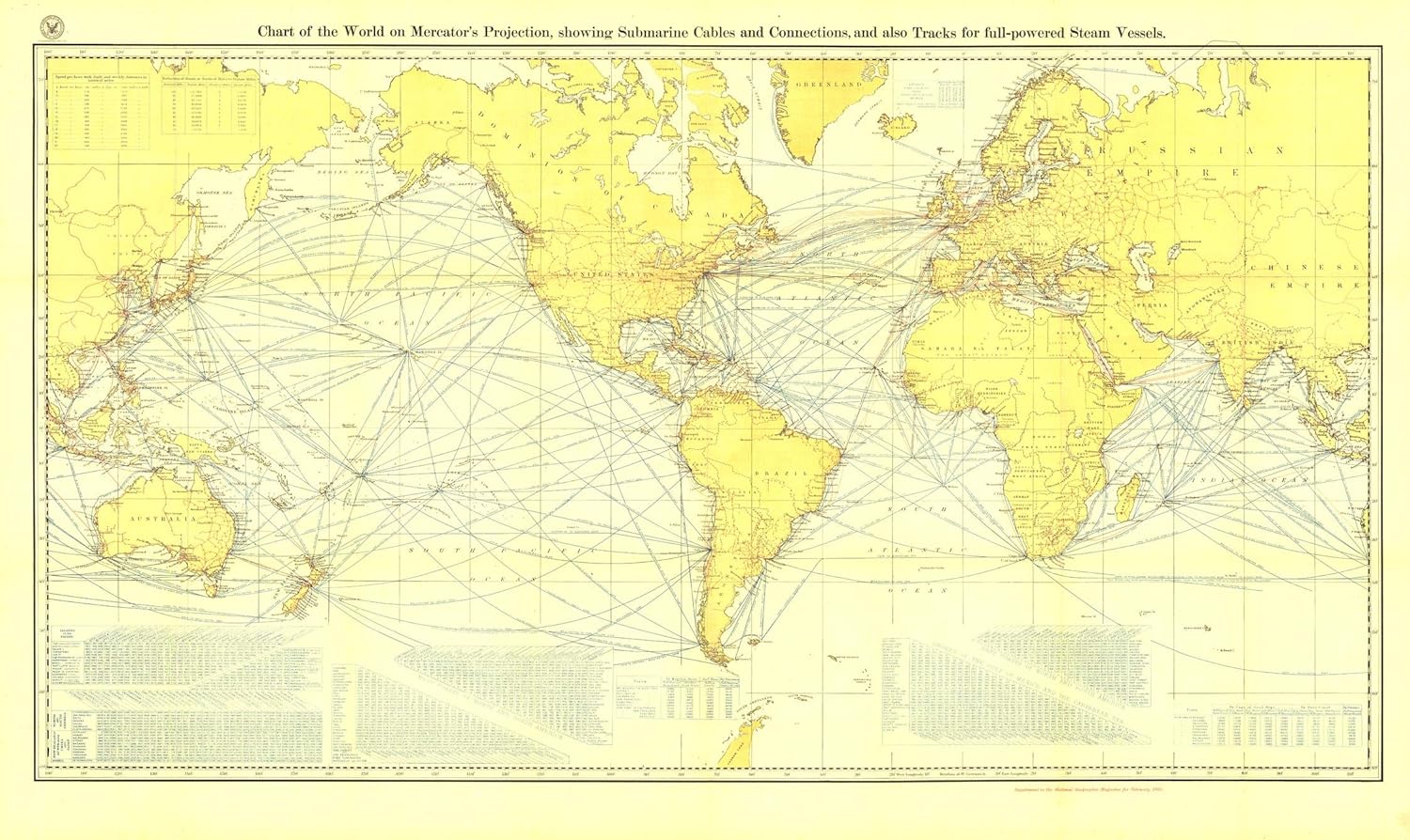
Submarine cables have played an important part in the development of world-wide communications since the 1850's. National Geographic first charted these cables in 1896, and this 1905 map reveals the explosion of communications infrastructure and steam vessel routes worldwide at the beginning of the twentieth century. A perfect addition to any map collection or history class.After the introduction of the working telegraph in 1839, the idea of a submarine line across the Atlantic Ocean became more fact than fiction - a possible triumph of the future. Britain's vast colonial empire spurred innovation in telegraph cable-laying from the first line laying across the English Channel in 1851 that connected the UK to continental Europe to the first trans-pacific cable lines in 1902-03. Over 99% of data traffic traveling across oceans still use submarine cables today, making this map a snapshot of the development of modern-day communications infrastructure.The legends featured on this map are a treasure for anyone interested in nautical history, featuring the names of ports and distances between ports connected by the submarine cables. A striking visual of yellows, reds and blues, the map is stamped with the seal of the Hydrographic Office of the American Department of the Navy.This map is drawn in the Mercator projection, which is a cylindrical map projection for nautical navigation because it represents lines of constant course, known as rhumb lines or loxodromes, as straight segments that conserve the angles with the meridians. Printed on polypropylene, an ideal material for wall maps as the printing brings out rich colours, and crisp edges for readability. The material is stronger than most papers and unlikely to crease or rip. The matte finish eliminates glare, and adds texture to the map. Ideal for display.Your map is rolled and packaged in a sturdy tube to protect it during shipment.
- A MUST-HAVE FOR TELECOMMUNICATIONS BUFFS: This map is a snapshot of the global telecommunications network that would explode over the following century. Hang a piece of history on your wall!
- QUALITY PRINT: Printed on Polypropylene for rich clear colour and legibility. Makes for a beautiful product on your home, school or office wall.
- DURABLE MATERIAL: This quality print material won't easily crease or tear in shipping or with use
- ICONIC CARTOGRAPHY: National Geographic's maps are the standard others are measured against. You can count on this product having the highest quality content and display in the industry.
| UPC | 749717025370 |
|---|---|
| Brand Name | National Geographic |
| Paper Size | 46.75 x 27.75 Inches |
| Manufacturer | MapSherpa |
| Paper Finish | Matte |
| Item Dimensions L x W | 46.75"L x 28"W |
Bestseller ranking
Posters & Prints


Customers who viewed this product also viewed
Pickups & Pickup Covers


Correction of product information
If you notice any omissions or errors in the product information on this page, please use the correction request form below.
Correction Request Form